The Eagletail Wilderness and KOFA National Wildlife Refuge
Posted: Tue Jun 21, 2011 12:58 am
Click Image to See the Full Picture, as they're not formatted correctly for the Pajero Owners Club of South Africa. Cheers.
The Eagletail Wilderness and KOFA National Wildlife Refuge are in Western Arizona, USA.
The Eagletail Wilderness and Kofa National Wildlife Refuge in Western Arizona.
KOFA stands for King of Arizona, and was named for a mine in the area. The refuge was also used during WWII by General Patton to train American ground troops for operations in North Africa. I guess the climate and terrain is similar. In the official information flyer, it warns visitors not to touch anything that resembles military hardware, and to report its position to the refuge office in Yuma... anyway..
I awoke on Monday morning needing to leave my Tempe flat. My quandary the day before, however, had been deciding upon a destination. It is beginning to get hot in Arizona’s Sonoran Desert, so a trip north to the higher elevations of the Mogollon Rim or the San Francisco Peaks would bring welcome relief, but I wanted to save an adventure like that for a day I could take my wife and step daughter, perhaps in two vehicles, with the Pajero and my friend Brian’s Jeep Wrangler. When I awoke, I knew, I would return to the Eagletail Wilderness and KOFA National Wildlife Refuge to its west, and instead of trekking overland through the Yuma Proving Ground (sort of illegal, but a way I’ve gone a half dozen times), I would seek a northern entrance through the wilderness at KOFA’s Northeast boundary.
After I dressed carelessly, I left around 5am with Katie Matilda my Australian Cattle Dog, jumped into the Pajero, and set off for Interstate 10, for a 65 mile drive to Harquahala Valley Road west of Tonopah, Arizona, stopping in Goodyear for breakfast at Jack in the Box. I had a chorizo burrito and diet Coke, Katie had a Breakfast Jack.
Harquahala Valley Road runs south, where we turned onto a dirt road. The road, or trail, marked Arlington Clanton Well Road, was completely unmaintained, and at some point it forked to the south without me even noticing. I kept checking the GPS coordinates, and topographical features, and established that I was on a trail just 2 miles south of the trail I needed to be on, and about to turn south, and further away from the Eagletail Wilderness, where I wanted to be. I turned north and navigated off road across desert pavement (large stretches of petina coated rocks), washes, foliage, and hills, until I got back onto the right track... and then began my way into Eagletail west towards KOFA National Wildlife Refuge. Rather than take the southern route, which I'd done several times, through Engineer Pass and an old fireman's cabin, I decided to try and find a northern route into the refugure, but that was tricky, as some of the trails on my Delorme Atlas and Gazateer have been made off limits, and disguised to make them unseen.. Eventually, I did find a more direct gasline trail, which took me into the refuge.. a place of bighorn sheep, miner's cats, eagles, and a plethora of desert critters, plants, and trees. My entire trip across the wilderness and refuge clocked on about 140 miles through the desert, and I saw not one other human being the entire trip... it was just me and my dog Katie, in the wilds of the desert.

I have no idea what this insect is, but it was quite large and scary.. probably 2.5 to 3 inches long. It's blurry as the thing was quick and went and hid from me before I could set my camera to auto.

It hasn't rained in ages, being a desert of course, and I made a Tauareg Turban to protect my head and to keep some of the dust out of my lungs... Moroccan style.
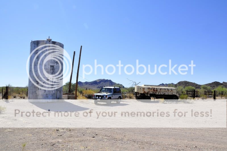
One of my first base camps that I used to use to camp at before starting out into the wilderness. It’s an abandoned well with a stock pen for cattle.


Inside driving thru Burro Canyon in Kofa.


Trianna after the trip, wearing the turban.. sorry this is all out of order.

Katie Matilda trying to round up some of the range cattle. She is so smart!


Oh, ya like the green stripe?


Scary cliff.


No problems, just adding some oil. Despite the hot temperatures, 43 celcius, the motor remained cool.


Awwwwwwwwwwwwwwwwwwwwwwwwwwwww!


I've found this marker before.. it's on the off road section between the two trails out in Eagletail... It marks a boundry line between Maricopa and Yuma County.. this helped me confirm my position on the map.


I'd hate to be stuck out here without water...


This is the marker at the NE Section of Kofa where I entered on the gasline trail.

It was an amazing trip.. and the only damage to the Pajero was a broken window crank handle on the passenger side (the fourth), one of the cargo bars over the windows on the interior of the rear fell off, and I needed a new air filter.
The Eagletail Wilderness and KOFA National Wildlife Refuge are in Western Arizona, USA.
The Eagletail Wilderness and Kofa National Wildlife Refuge in Western Arizona.
KOFA stands for King of Arizona, and was named for a mine in the area. The refuge was also used during WWII by General Patton to train American ground troops for operations in North Africa. I guess the climate and terrain is similar. In the official information flyer, it warns visitors not to touch anything that resembles military hardware, and to report its position to the refuge office in Yuma... anyway..
I awoke on Monday morning needing to leave my Tempe flat. My quandary the day before, however, had been deciding upon a destination. It is beginning to get hot in Arizona’s Sonoran Desert, so a trip north to the higher elevations of the Mogollon Rim or the San Francisco Peaks would bring welcome relief, but I wanted to save an adventure like that for a day I could take my wife and step daughter, perhaps in two vehicles, with the Pajero and my friend Brian’s Jeep Wrangler. When I awoke, I knew, I would return to the Eagletail Wilderness and KOFA National Wildlife Refuge to its west, and instead of trekking overland through the Yuma Proving Ground (sort of illegal, but a way I’ve gone a half dozen times), I would seek a northern entrance through the wilderness at KOFA’s Northeast boundary.
After I dressed carelessly, I left around 5am with Katie Matilda my Australian Cattle Dog, jumped into the Pajero, and set off for Interstate 10, for a 65 mile drive to Harquahala Valley Road west of Tonopah, Arizona, stopping in Goodyear for breakfast at Jack in the Box. I had a chorizo burrito and diet Coke, Katie had a Breakfast Jack.
Harquahala Valley Road runs south, where we turned onto a dirt road. The road, or trail, marked Arlington Clanton Well Road, was completely unmaintained, and at some point it forked to the south without me even noticing. I kept checking the GPS coordinates, and topographical features, and established that I was on a trail just 2 miles south of the trail I needed to be on, and about to turn south, and further away from the Eagletail Wilderness, where I wanted to be. I turned north and navigated off road across desert pavement (large stretches of petina coated rocks), washes, foliage, and hills, until I got back onto the right track... and then began my way into Eagletail west towards KOFA National Wildlife Refuge. Rather than take the southern route, which I'd done several times, through Engineer Pass and an old fireman's cabin, I decided to try and find a northern route into the refugure, but that was tricky, as some of the trails on my Delorme Atlas and Gazateer have been made off limits, and disguised to make them unseen.. Eventually, I did find a more direct gasline trail, which took me into the refuge.. a place of bighorn sheep, miner's cats, eagles, and a plethora of desert critters, plants, and trees. My entire trip across the wilderness and refuge clocked on about 140 miles through the desert, and I saw not one other human being the entire trip... it was just me and my dog Katie, in the wilds of the desert.
I have no idea what this insect is, but it was quite large and scary.. probably 2.5 to 3 inches long. It's blurry as the thing was quick and went and hid from me before I could set my camera to auto.
It hasn't rained in ages, being a desert of course, and I made a Tauareg Turban to protect my head and to keep some of the dust out of my lungs... Moroccan style.
One of my first base camps that I used to use to camp at before starting out into the wilderness. It’s an abandoned well with a stock pen for cattle.
Inside driving thru Burro Canyon in Kofa.
Trianna after the trip, wearing the turban.. sorry this is all out of order.
Katie Matilda trying to round up some of the range cattle. She is so smart!
Oh, ya like the green stripe?
Scary cliff.
No problems, just adding some oil. Despite the hot temperatures, 43 celcius, the motor remained cool.
Awwwwwwwwwwwwwwwwwwwwwwwwwwwww!
I've found this marker before.. it's on the off road section between the two trails out in Eagletail... It marks a boundry line between Maricopa and Yuma County.. this helped me confirm my position on the map.
I'd hate to be stuck out here without water...
This is the marker at the NE Section of Kofa where I entered on the gasline trail.
It was an amazing trip.. and the only damage to the Pajero was a broken window crank handle on the passenger side (the fourth), one of the cargo bars over the windows on the interior of the rear fell off, and I needed a new air filter.